West Coast of Vancouver Island - Geographic Area
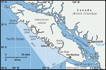 The west coast of Vancouver Island (WCVI), British Columbia (BC), Canada, is a highly productive upwelling area off the west coast of North America. This area supports some of British Columbia’s largest fisheries. Since 1973, Fisheries and Oceans Canada (DFO) has conducted a fishery-independent, multispecies small mesh bottom trawl survey annually in a portion of this area off the WCVI (statistical areas 124 and 125). This survey was initially designed to sample shrimp populations, but catches many species of fish and is, hereafter, referred to as the multispecies survey. The data from this survey in statistical areas 124 and 125 were used in analyses for the WCVI. In 1976, the survey gear was altered from a semi-balloon trawl with flat wood doors and a bobbin and roller groundline to a National Marine Fisheries Service (NFMS) high-rising shrimp survey trawl net with steel Vee Doors (Boutillier et al. 1976). The area covered by the survey is approximately 4,707 km2 (statistical areas 124 and 125 combined) and stations are sampled at depths between 50 and 200 m during late April to May. This is the longest survey time series available for the WCVI area; however, it is important to note that it covers a limited area and depth range and, therefore, does not effectively sample all fish and invertebrate species in deeper depths or in nearshore areas. In 2003, groundfish synoptic surveys in all offshore areas off WCVI were initiated which, when the time series is longer, will provide an additional and valuable long term data series on groundfish species. In addition to survey data, commercial fisheries catch data were utilized in analyses for the WCVI. Commercial catch data are available in BC for DFO statistical areas 24/124, and 25/125, overlapping spatially and temporally with data from the fishery-independent multispecies bottom trawl survey (statistical areas 124 and 125). This area is in the FAO major fishing area 67 which is defined by the coordinates: 47°27.433?N, 127°30.767?W, 49°00.000?N, 128°14.703?W, 49°51.564?N, 127°09.127?W, and 48°59.659?N, 125°37.667?W.
FAO Fishing Areas: [ 67 ]