USA (North-East) - Geographic Area
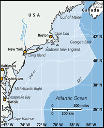 The Northeast United States continental shelf large marine ecosystem (hereafter, NEUS) includes the Gulf of Maine, Georges Bank, Southern New England and Mid-Atlantic regions (Sherman 1991). The Gulf of Maine (GoM) averages 150 m in depth, has numerous deeper basins with sill depths of 59 to 242 m, and numerous ridges which shoal as shallow as 9 m. Georges Bank (GB) flanks the Gulf of Maine (GoM) on the ocean side to the south and is a large topographic high that rises above the GoM, with an average depth of 70 m. Southern New England (SNE) is west of Georges Bank and has an average depth of 60 m. The Mid-Atlantic Bight (MAB) is south of SNE, is a much narrower part of the continental shelf and is oriented predominately N-S as compared to GB and SNE which are E-W in orientation. The MAB averages 35 m depth. Overall the entire NEUS ecosystem covers an area of 293,000 km2 (approximately 85,300 nautical miles2) from Cape Hatteras, NC to Nova Scotian waters of the Northwest Atlantic. The Northeast Shelf Large Marine Ecosystem (LME; Sherman 1991) forms a unique biogeographic province among western Atlantic ecosystems.
FAO Fishing Areas: [ 5Y ; 5Zu ; 5Zw ; 6A ; 6B ; 6C ]