Senegalese EEZ - Geographic Area
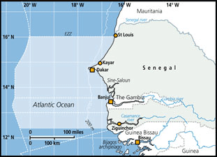 Senegal covers 196,722 km2 between 12 ° and 17 ° N and 11 ° and 18 ° W, having an important coastline extending for about 700 km. The coast is mainly rocky in the peninsula of Cape Verde, and sandy or muddy and sandy elsewhere.
The continental shelf is limited by the 200-meter isobath, and covers an area of about 23092 km2. It extends from about 27 nautical miles off the coast of St. Louis, but narrows to 5 miles in vicinity of the peninsula of Cape Verde. In southern Cape Verde, the continental shelf widens progressively to 87 nautical miles in the Casamance.
The sediment of the continental shelf can be divided into three types: muddy grounds, sandy grounds and rocky shoals. The EEZ of Senegal, limited by the area of 200 nautical miles, represents an area of 158,861 km2.
FAO Fishing Areas: [ 34 3.12 ]