Rufiji-Mafia Channel - Geographic Area
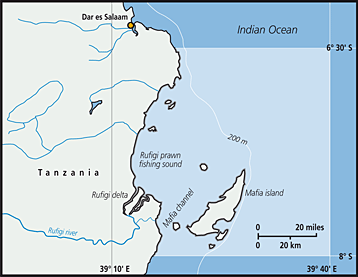 The Rufiji–Mafia channel ecosystem is located on the east coast of Tanzania, between latitudes 060 56?S and 08000? S and longitudes 39°10?E and 39° 40?E. This ecosystem consists of the Rufiji delta and the Mafia Channel within the bounds described above. The Rufiji delta is crescent shaped, 23 km wide and 65 km long and protrudes 15 km into the Mafia channel, covering an area of about 1200 km2. The Rufiji coastline is approximately 90 km long dominated by the largest estuarine mangrove forest in East Africa, with an estimated coverage of 559 km2. The Mafia Channel is a stretch of water between the Rufiji Delta and Mafia Island, deep enough for navigation through the area. The connection of Rufiji and Mafia Channel is linked to the system of ocean currents and coral reefs, extruding towards the Mafia Island in the East and this influences fisheries production in the Islands of Zanzibar (Unguja and Pemba) through the northerly flow of marine currents. The Rufiji Delta is the most productive fishing ground in Tanzania contributing about 45% of the total annual production of prawns. The dominant species of prawn are Metapenaeus monoceros and Penaeus indicus.
FAO Fishing Areas: [ 51.5 ]