Benguela (Southern) - Geographic Area
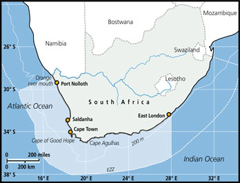 The Benguela is an upwelling system that may be subdivided into two oceanographic sub-systems. The northern Benguela is considered to extend south of the Angola-Benguela front located between 14 and 16oS, southwards to the permanent upwelling cell located in the vicinity of Lüderitz, Namibia (26oS). The latter is believed to provide a barrier to the north-south migration of some fish stocks, such as anchovy and sardine. However, the conventional division between northern and southern sub-systems is the Namibian-South African border at the Orange River Mouth (29oS). For scientific and fisheries management purposes, the southern Benguela ecosystem is generally assumed to extends from the Orange River Mouth (29oS) to East London (28oE), offshore to approximately the 500-m depth contour, covering an area of 220 000 km2.
FAO Fishing Areas: [ 47.1.6 ; 47.2.1 ; 47.2.2 ]