Bay of Ambaro (Madagascar) - Geographic Area
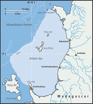 The Bay of Ambaro located on the North-West of Madagascar extends from Cap Saint Sébastien in the North to the village of Ampapamena in the South, and from the coastline on the East to the continental slope seawards, within the coordinates 12°25 S – 13°26S and 48°30 E – 48°48 E. The bay is largely open on the continental shelf of 35 to 40 nm width which narrows northern Cap Saint Sébastien, and is sheltered from open sea influence. According to Piton and Magnier (1971), the Bay of Ambaro could be classified as a plain estuary, the circulation being characterized by two layers acting as traps of organic matter which pile up and mineralize close to the coast. Many rivers discharge into the bay, draining sediment that silts in the bay specifically during the rainy season. The seabed is muddy to sandy-muddy, sprinkled with fringing reefs or banks. On this landscape, the Mitsio archipelago stands in the middle of the area, surrounded by reefs. The coastal side of the bay is covered by 27,000 ha of mangrove formations, serving as nurseries for many marine species, including peneid shrimps and fish. This area constitutes an individualized management area (Zone A) in terms of shrimp fisheries.
FAO Fishing Areas: [ 51.1 ]